7 nights · default stay

Brazil · Expedition · Nature · Ecotourism

Monte Roraima

Monte Roraima is a spectacular sandstone plateau reached by a demanding expedition through Venezuela. Serious border-region travel warnings currently affect the usual route.

Recommended stay6–8 nights
Ease of travel1/10
First Brazil trip4/10
Infrastructure2/10
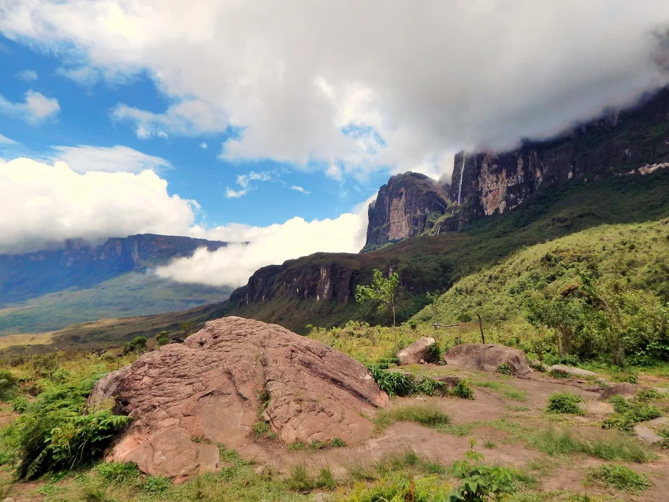
Base of Monte Roraima in northern Brazil
5.14°N · 60.76°W Expedition
Photo: Mauricio Campello · CC BY-SA 4.0

Why this place

Monte Roraima

Monte Roraima is one of Brazil’s defining expedition destinations: a vast table mountain on the borders of Brazil, Venezuela and Guyana. Most trekking itineraries begin from Boa Vista, cross into Venezuela and approach the mountain through the Gran Sabana before several days of walking and camping. The summit rewards the effort with sandstone formations, crystal valleys, endemic plants and a landscape that feels unlike conventional mountain travel.

Monte Roraima looks like a natural fortress rising above the Gran Sabana. Its isolated sandstone plateau, weather-carved rocks and endemic plants make it one of South America's great landscapes. Yet photographs of a cloud-ringed tepui can disguise how different this is from a Brazilian national-park day trip. The established visitor approach runs from Boa Vista toward Pacaraima, crosses into Venezuela near Santa Elena de Uairén and continues to Paraitepuy, where a guided walk of several days begins. The Brazilian side has protected and Indigenous lands, not a casual alternative gate to the top.

Before considering an expedition, check current government travel warnings rather than relying on a guide's available dates. As verified on 4 November 2026, the UK advises against all travel within 40 km of Venezuela's borders with Brazil and Guyana, a zone encompassing the normal route; Germany also warns against travel to the Venezuelan border states concerned. Advice and insurance rules depend on your nationality and can change quickly. When official warnings apply, postpone the ascent instead of trying a back route. For a Brazil-only mountain experience, investigate Serra do Tepequém rather than confusing the two destinations.
Before you book

Monte Roraima: check the Venezuela travel warnings before booking

The usual ascent is a multi-day expedition via Venezuela, inside a region covered by serious government travel warnings as of November 2026.

01

Current border travel warnings come before tour availability

As checked on 2 November 2026, Germany warns against travel to Venezuelan states bordering Brazil and Guyana, while the UK advises against all travel within 40 km of either border. Monte Roraima's established approach via Santa Elena and Paraitepuy falls in this high-risk border region. Check your own government's live advice and whether insurance or emergency assistance would apply. When the advisory discourages the route, postpone the expedition; a tour agency's willingness to sell it is not safety clearance.

02

One border crossing, a Pemón community and several trekking days

The Brazilian Ministry of Tourism describes the approach via Boa Vista, Pacaraima, Santa Elena and Paraitepuy on the Venezuelan side; INPARQUES describes Monte Roraima as a strenuous multi-day climb in Canaima National Park and recognises Pemón communities as guardians of the tepuis. Brazilian domestic travel arrangements do not establish permission to enter Venezuela or use Indigenous or protected areas. Confirm immigration rules for every passport, current border operations, local guide and community arrangements, and legal camping access directly before any payment.

03

If travel becomes feasible, compare the whole expedition and backup

Ask in writing who supplies qualified local guides, porters, tents, food, drinking-water treatment, waste removal, river-crossing decisions, satellite/emergency communications, evacuation support and additional days. There is no short independent Brazilian public access route implied by the map pin. Changing storms, terrain and border operations can affect the return. Do not schedule a same-day onward flight or buy a nonrefundable trip while serious official travel warnings still apply.

At a glance

Brasilll scorecard

The same 0–10 scale is used across the catalogue, so strengths and compromises stay comparable.

These are editorial fit ratings, not visitor-review averages or safety guarantees. A high score describes a strength for a particular kind of trip. How to read these scores →

Culture7/10
Food4/10
History6/10
Nightlife1/10
Beach0/10
Nature10/10
Wildlife8/10
Adventure10/10
Local feel9/10
Photography10/10
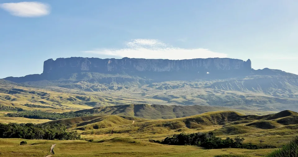
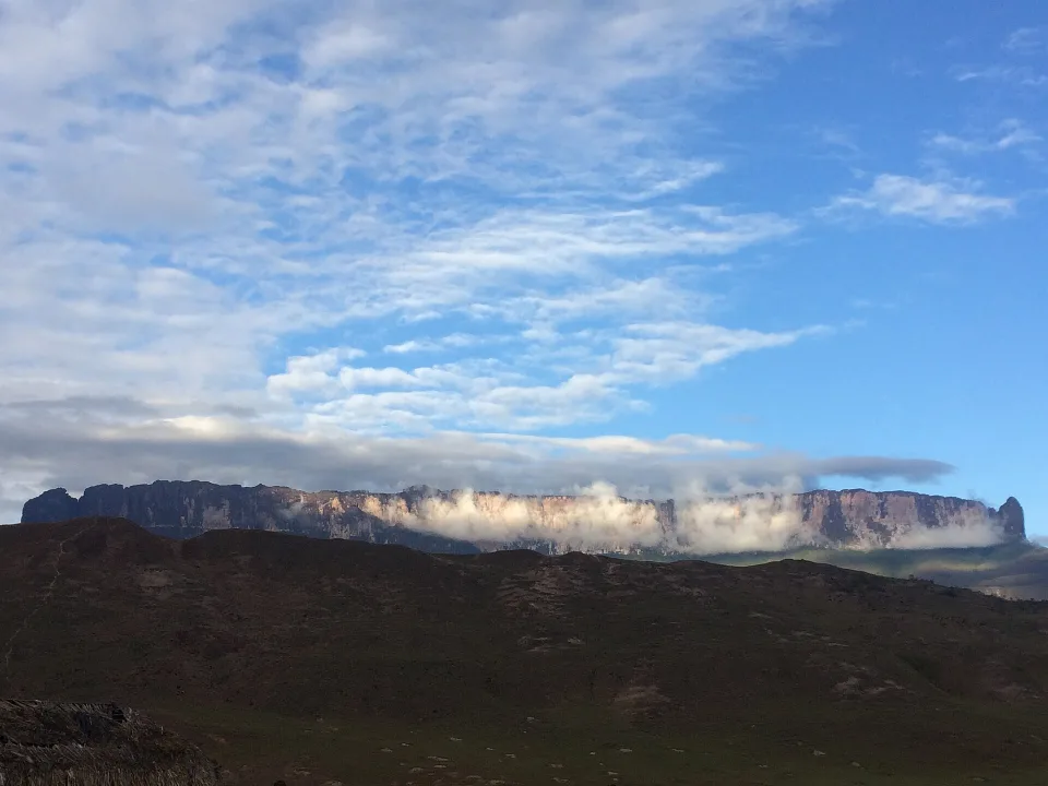
Original wide photograph of the flat-topped Monte Roraima seen from the road to Paraitepuy in Venezuela's Gran Sabana
Photo: Paolo Costa Baldi / Wikimedia Commons · CC BY-SA 3.0 · Cropped for layout

The mountain rises from another country

The Venezuelan approach: a mountain beyond Brazil's border

This genuine 2010 photograph shows Monte Roraima from the road leading toward the Pemón community of Paraitepuy, on Venezuela's Gran Sabana. The established trekking route from Boa Vista crosses into Venezuela before the multi-day hike; it does not begin at a Brazilian summit trailhead. As of November 2026, UK and German government warnings cover this border region. Check the advisories for your nationality before any deposit, and postpone the expedition while official warnings advise against the route.

Understand the route and the current border warnings

Where to stay

Roraima is a Venezuela-based multi-day expedition, not a quick Brazilian summit hike

The normal approach has four distinct stages: Boa Vista as transport hub, the Brazil–Venezuela border at Pacaraima/Santa Elena, the Pemón starting community at Paraitepuy, and the remote plateau. Current official travel warnings affect the international stages; a Brazilian map pin does not establish a public summit route.

Boa Vista — transport gateway, not the trekking trailhead

Brazil's Ministry of Tourism identifies Boa Vista as the practical start for the northbound border route. Booking a hotel in the capital does not provide access to the mountain: the operator must organise vehicle transfers, border documents, the overnight schedule, gear and emergency arrangements.

Pacaraima and Santa Elena de Uairén — the international border stage

The usual trekking approach leaves Brazil near Pacaraima, passes into Venezuela and continues through the Gran Sabana. Verify the current crossing and requirements with official immigration authorities for your nationality; Brazilian domestic ID rules alone cannot be assumed sufficient for every traveller.

Paraitepuy — the community departure point on the Venezuelan side

The Ministry of Tourism describes Paraitepuy as the village from which roughly week-long guided trips begin. Community guides, load carriers, permitted camp areas and food are part of the agreed expedition, not casual services you can expect to find without a reservation.

The sandstone plateau and Brazilian border sector — different access rights

The summit plateau is a remote high-altitude hiking landscape near three countries. The normal trail climbs from Venezuela; protected Indigenous and park lands on the Brazilian side do not create an alternative unrestricted walking gate. Stay on authorised routes and respect fragile plants, camps and local community rules.

Travel smarter

Three non-negotiable checks before committing to Monte Roraima

A few practical decisions before departure can save time and make the experience easier on the ground.

01

Can I summit directly from the Brazilian national park?

Do not assume it. The established visitor trekking approach described by the Ministry of Tourism crosses into Venezuela and begins near Paraitepuy. A Brazilian park boundary or a pin on the map is not an authorised public trail.

02

Is the crossing into Venezuela covered by a Brazilian domestic tour booking?

No. Confirm passport, entry permission, travel advisories, health requirements and the operator's documented border procedures for each passport before paying. Rules can change independently of the hike's advertised season.

03

Does a seven-day tour include every service and safety measure?

Not automatically. Ask who supplies tents, meals, licensed local guides, porters, waste removal, emergency communication and rescue arrangements. Weather and fitness can change the route or require additional days.

Weather & timing

When to go

Season matters. These monthly scores combine our current baseline for climate, access and overall travel fit.

Monthly ratings are broad planning guidance, not a weather forecast or confirmation that every activity is operating.

Jan10/10
Feb10/10
Mar9/10
Apr8/10
May6/10
Jun6/10
Jul6/10
Aug7/10
Sep8/10
Oct8/10
Nov9/10
Dec10/10

Build your route

A realistic seven-day mountain example rather than a three-day city break

This seven-day outline explains the scale of a possible future expedition, not a trip to book under today's travel warnings. Check your government's advisory first, then only when conditions change evaluate community-led guiding, border access, several trekking days and a safe return buffer.

Days 1–2

First check whether travelling to the border is appropriate

Before paying a deposit for a Boa Vista–Pacaraima–Santa Elena–Paraitepuy expedition, examine the official advisory for every country and passport involved. As of 2 November 2026 Germany warns against travelling to Venezuelan states bordering Brazil and Guyana, while the UK advises against all travel within 40 km of these borders. The usual trekking approach crosses this risk area; having a commercial operator does not cancel travel warnings or guarantee insurance. If advice applies, postpone the ascent and consider a Brazil-only alternative. Only after conditions allow should you confirm the community-approved guide, immigration, transfers and rescue procedures.

Days 3–5

The plateau requires a serious expedition, not a day hike

If travel becomes possible under current safety and access rules, the typical Venezuelan route begins with Pemón community arrangements near Paraitepuy, crosses savanna and rivers and climbs steeply toward the plateau. INPARQUES describes Monte Roraima in Canaima National Park as a strenuous multi-day trek through sensitive ecosystems. Confirm the number of mountain nights, local guides, allowed camps, food and water, waste removal, weather delays and satellite or emergency communication. The mountain's triple-border geography is not permission to wander across Brazilian or Guyanese protected territory without authorization.

Days 6–7

Descend only with a realistic return and cancellation buffer

Even on an appropriately authorised future trip, the descent is followed by multiple road and border stages through Santa Elena before Boa Vista. Rain, river levels, difficult terrain and changing border procedures may cause delays or cancellations. Agree written conditions for a missed return boat or vehicle, medical evacuation, equipment and additional camp days; never assume a tour runs regardless of weather. Leave at least a practical buffer before onward flights. If the government warnings still cover the route, a responsible itinerary is to defer rather than improvise a shortcut from the Brazilian national park.

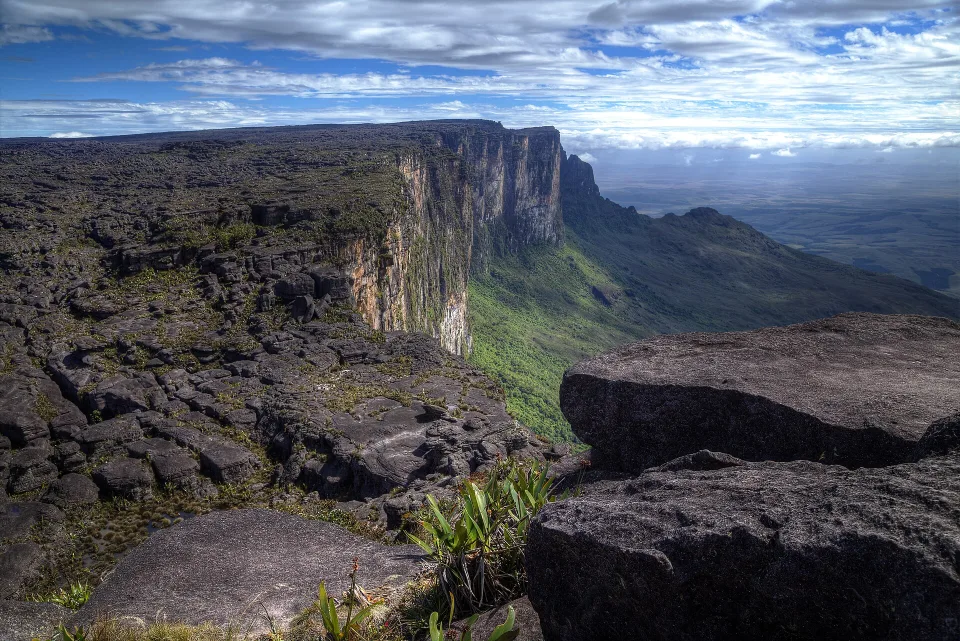
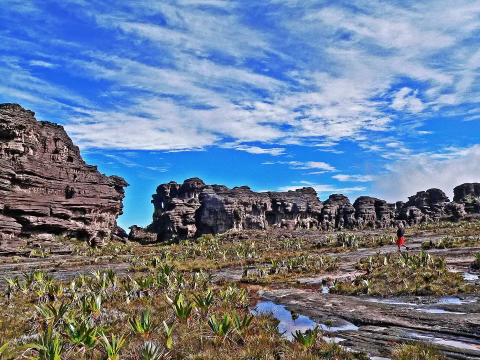
Verified original photograph of the rocky highest point on the Venezuelan summit plateau of Monte Roraima
Photo: Tinhojv / Wikimedia Commons · CC BY-SA 4.0 · Cropped for layout

An extraordinary but fragile summit

On the plateau: sandstone, weather and strict responsibility

This original photograph from December 2015 documents the highest point on the Venezuelan side of Monte Roraima. The plateau's unusual sandstone landscape is the reward of several hard trekking days, not a lookout reachable by car or a casual day hike. If an expedition becomes appropriate under future safety guidance, arrange Pemón community guides, permitted camps, food, weather contingencies and waste removal before travelling. Fragile summit habitats are not a place to improvise routes, collect crystals or camp wherever you like.

Read the realistic multi-day expedition plan

Travel styles

Who does it suit?

These comparative scores show who is likely to enjoy this destination most—and where expectations may need adjusting.

Repeat Brazil travellers10/10
Active travellers10/10
Friends9/10
Slow travel8/10
Backpackers8/10
Couples8/10
Solo6/10
Families with teenagers5/10

Brasilll

How long should you stay?

We recommend 6–8 nights as a starting point. Include the arrival and departure journeys in your plan, then adjust the stay around the local outings you choose.

The recommended six to eight nights describe the scale of an expedition, not a currently recommended booking. A typical future itinerary needs travel to Boa Vista, international road transfers, a Pemón community departure near Paraitepuy, several nights on the trail or plateau and time to descend. The illustrated seven-day route below is a planning example only. With the present border warnings, treat it as background for a later trip when official safety and access guidance changes.

If conditions eventually make an organised visit appropriate, ask for a complete written breakdown before paying: guide and community permissions, immigration documents, vehicles, tents, sleeping gear, meals, water treatment, porter limits, waste removal and return travel. Mountain rain and exposed sandstone make even routine stages demanding; build a delay and evacuation plan with emergency communications. Do not enter restricted park or Indigenous areas without consent, pick up geological specimens or cross international boundaries on the plateau without authorisation.

Found an outdated price, route or detail? Send the page URL, the information that needs changing and a supporting source if available.

Report an error →

Does this sound like your Brazil?

Use Find Your Brasil to compare this destination with the rest of the country using your own priorities.

Plan Brazil

Getting there & moving on

Use these rounded door-to-door estimates to judge the travel day. Confirm the actual service and departure time before booking.

Arrival base

Boa Vista

Typical access Road

Start by agreeing the expedition’s meeting point and full route with the operator. The usual trekking approach involves a Venezuela border stage; confirm the current crossing arrangements for your nationality.

Good onward connections

These are selected options for your next stop. Confirm operating days, connections and total travel time for your dates.