5 nights · default stay

Brazil · Beach · Nature · Ecotourism

Ilha do Mel

No cars, just Atlantic Forest, sand trails and beaches. Pick your boat landing carefully and explore Ilha do Mel on foot, from the fortress to the sea cave.

Recommended stay4–5 nights
Ease of travel5/10
First Brazil trip7/10
Infrastructure5/10
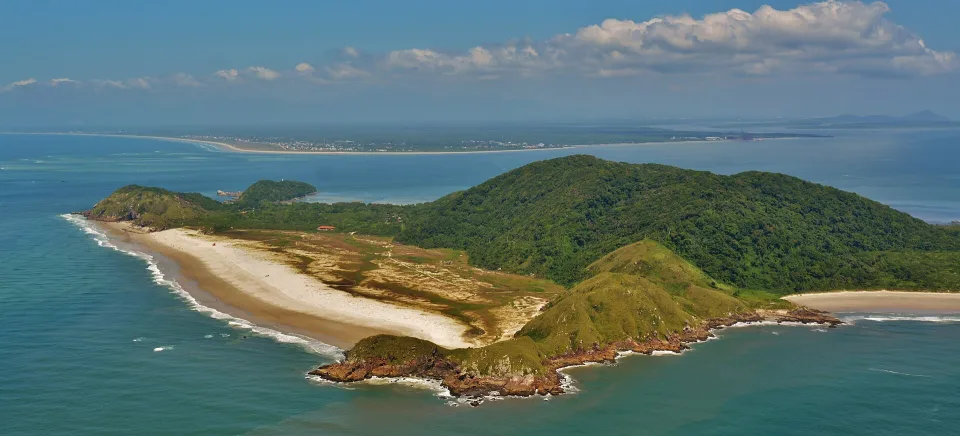
Farol and Istmo beaches seen from Farol das Conchas on Ilha do Mel, Paraná
25.54°S · 48.30°W Beach
Photo: Everton.photography · CC BY-SA 4.0

Why this place

Ilha do Mel

Ilha do Mel is a protected island where the journey slows down as soon as you step off the boat. Visitors arrive from Pontal do Sul or Paranaguá and move mainly on foot or by bicycle between places such as Nova Brasília, Encantadas, Farol das Conchas, the fort and long beaches. Much of the island is protected land, so carrying less and planning around walking distances matters more than on a conventional beach holiday.

Ilha do Mel makes the journey feel different before the first walk. Most visitors cross from Pontal do Sul, where the Paraná conservation authority estimates about 30 minutes by boat; the longer departure from Paranaguá takes roughly 90 minutes. Boats serve different island landings. Choose a pousada in Nova Brasília or Encantadas first, then confirm that the operator actually stops there and that the arrival time suits your luggage. Sand paths and occasional bicycles replace taxis and car transfers. Heavy wheeled cases are a nuisance, especially after rain.

The island has two kinds of protected ground, and they are not interchangeable. IAT says the state park permits organised public visitation, while the ecological station is more restrictive and normally allows access only for authorised educational purposes. That is why a tempting shortcut across forest or dunes is not necessarily a permitted trail. Use signed routes, carry drinking water and take your litter out. Lighthouse, fort and cave are legitimate landmarks, but swimming, tide and rocky-shore safety still depend on the conditions of the day.
The Brasilll take

Ilha do Mel is not difficult because it is remote; it is different because the island makes you travel at walking speed.

Boats, sand paths and protected Atlantic Forest strip away the normal road-trip rhythm. Nova Brasília and Encantadas work as the two main practical bases, while beaches, the lighthouse and the fort are connected by walking rather than a street network. That simplicity is the attraction, but it also means choosing your base and packing light matter more than usual.

What makes Ilha do Mel special

01

No car changes the whole experience

Once you arrive, distance is measured in walking time, sand and weather rather than kilometres. The island feels slower because the transport system is your own legs and occasional bicycle use.

02

Protected nature is the main event

Atlantic Forest, dunes, long beaches and conservation areas dominate the island. The lighthouse and fortress add landmarks without turning the trip into conventional sightseeing.

03

Your base changes your trip

Nova Brasília works well for Farol das Conchas and northern walks; Encantadas creates a different rhythm around the southern beaches and cave area.

Before you book

Ilha do Mel: boat pier, island base and 2026 visitor registration

As of IAT's 15 October 2026 update, the new digital access system is registering residents first; tourist registration has no announced start date. Standard boat fares and wildlife-protection rules still matter.

01

Choose the boat to Nova Brasília or Encantadas, not just 'Ilha do Mel'

IAT lists Pontal do Sul and Paranaguá as the mainland departure points; the former is the shorter crossing. Select the correct island landing for your pousada, verify sailing hours and an authorised operator, and remember that only walking or cycling is permitted on the island. Carry luggage suitable for sand paths, and arrange a safe return before a flight or long road trip.

02

Do not confuse planned tourist access fees with today's rules

On 15 October 2026, IAT said the access-control project's first stage covers residents, with no charge in that phase. Tourist registration is a later phase with no confirmed start date yet; prior proposals about digital tickets or fees are not proof they currently apply. Check IAT's latest announcement just before travel and pay any required boat fare separately.

03

Protect your walking route around the park and ecological station

Nova Brasília is a practical northern base for Farol das Conchas and the fortress; Encantadas serves the southern cave and beaches. These are not adjacent vehicle-accessible stops. Use permitted trails, follow closures and tides, and do not shortcut across restricted ecological station areas. Estimate the full walking time from your actual arrival pier.

At a glance

Brasilll scorecard

The same 0–10 scale is used across the catalogue, so strengths and compromises stay comparable.

These are editorial fit ratings, not visitor-review averages or safety guarantees. A high score describes a strength for a particular kind of trip. How to read these scores →

Culture6/10
Food7/10
History7/10
Nightlife5/10
Beach10/10
Nature10/10
Wildlife8/10
Adventure9/10
Local feel9/10
Photography10/10
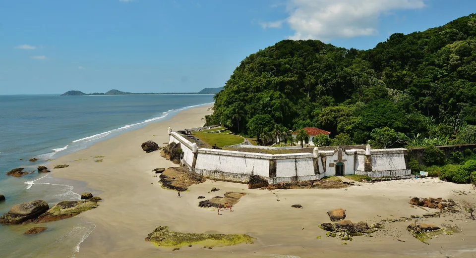
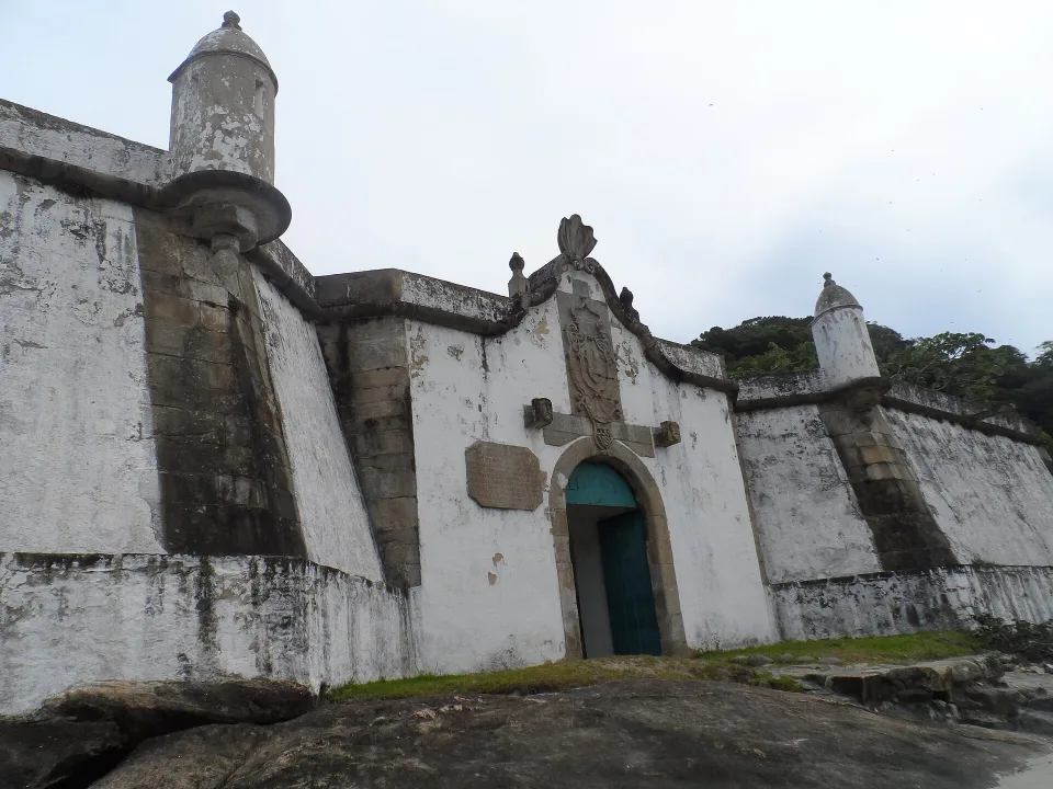
Original aerial panoramic photograph of Fortaleza Nossa Senhora dos Prazeres beside the forest and beach on Ilha do Mel, Paraná
Photo: Cyrus Augustus Moro Daldin / Wikimedia Commons · CC BY-SA 4.0 · Cropped for layout

History at the end of a long beach walk

Fortaleza Nossa Senhora dos Prazeres: plan the northern trail

Cyrus Augustus Moro Daldin’s 2013 original aerial photograph shows the eighteenth-century Fortaleza de Nossa Senhora dos Prazeres on Ilha do Mel’s northern coast. The fort is not beside the island’s southern landing. According to IAT, it is about four kilometres on foot from the Brasília pier, so keep time for sand, exposed weather and the way back. Use signed routes, bring drinking water and verify current access before setting out; the ecologically restricted parts of the island are not shortcuts.

Compare Nova Brasília, the lighthouse and Encantadas

Where to stay

Four useful anchors on the island

Base yourself according to the pier: Nova Brasília serves lighthouse and northern walks, Encantadas is better for the cave and southern beaches. The historic fort is a longer outing, not a stop beside either landing.

Nova Brasília

A practical base for the lighthouse, isthmus beaches and routes toward the fort, with enough services for several nights.

Farol das Conchas

The classic elevated view that explains the island’s narrow geography and two-sided coastline.

Encantadas

A second accommodation hub with a more southern orientation and easy access to beaches and Gruta das Encantadas.

Fortaleza de Nossa Senhora dos Prazeres

The island’s strongest historic landmark and a useful destination for a longer beach-and-trail day.

Travel smarter

Walking logistics are the real planning problem

IAT lists 30 minutes from Pontal do Sul versus about 90 from Paranaguá. Confirm the landing, return and current access rules; the October 2026 digital-registration phase initially concerned residents, not tourists.

01

Choose your arrival point before your pousada

Boat routes and walking distances matter. Make sure the landing point matches the area where you will sleep instead of assuming the island is tiny enough for luggage walks everywhere.

02

Pack lighter than you normally would

Sand paths, humidity and walking make wheeled luggage much less convenient than on a normal coastal trip.

03

Check current IAT access rules

Paraná has been changing visitor-control arrangements during 2026. Verify the current system before departure rather than relying on old fee or registration information.

Weather & timing

When to go

Season matters. These monthly scores combine our current baseline for climate, access and overall travel fit.

Monthly ratings are broad planning guidance, not a weather forecast or confirmation that every activity is operating.

Jan10/10
Feb9/10
Mar8/10
Apr7/10
May7/10
Jun6/10
Jul6/10
Aug7/10
Sep8/10
Oct9/10
Nov9/10
Dec10/10

Build your route

A relaxed four-day island stay

Keep the four days unhurried: land near your pousada, visit the lighthouse when weather is good, give the fortress its own walk, and explore Encantadas without cutting through conservation land.

Day 1

Arrive and learn your side of the island

Take the scheduled boat or an authorised water taxi from Pontal do Sul or Paranaguá, choosing the island landing that matches your booked pousada in Nova Brasília or Encantadas. IAT gives a much shorter crossing from Pontal do Sul than from Paranaguá, and there are no visitor cars on the island. Confirm operator, luggage rules, exact pier, the last return boat and your sand-path walk before travelling with heavy wheeled suitcases.

Day 2

Lighthouse and northern beaches

Use a clear-weather day for the Farol das Conchas viewpoint and beaches accessible from Nova Brasília, staying on permitted trails through the protected landscape. The lighthouse walk has steps and exposed sections; check the beach tide and return path rather than treating every cove as connected by flat pavement. If sleeping in Encantadas, account for the separate island transfer or long sand walk before setting out.

Day 3

Longer trail or fortress day

Choose Fortaleza de Nossa Senhora dos Prazeres as a longer northern beach-and-history outing, with enough daylight to walk back via permitted paths. The state tourism guide places the fortress away from the Encantadas landing, so verify true walking effort from your hotel and current conservation closures. Carry drinking water and avoid trying to cross restricted ecological-reserve terrain as a shortcut.

Day 4

Encantadas or simply slow down

Spend the last day close to Encantadas for Gruta das Encantadas and the southern beaches, or choose a quieter local walk if your hotel is on the northern side. Coastal rock access, tides and surf can change; follow posted protections and avoid sensitive dunes. On 15 October 2026 IAT said its new digital registration had begun with residents only, with tourist registration date not yet set and no charge in that first phase. Recheck the official update before returning by boat.

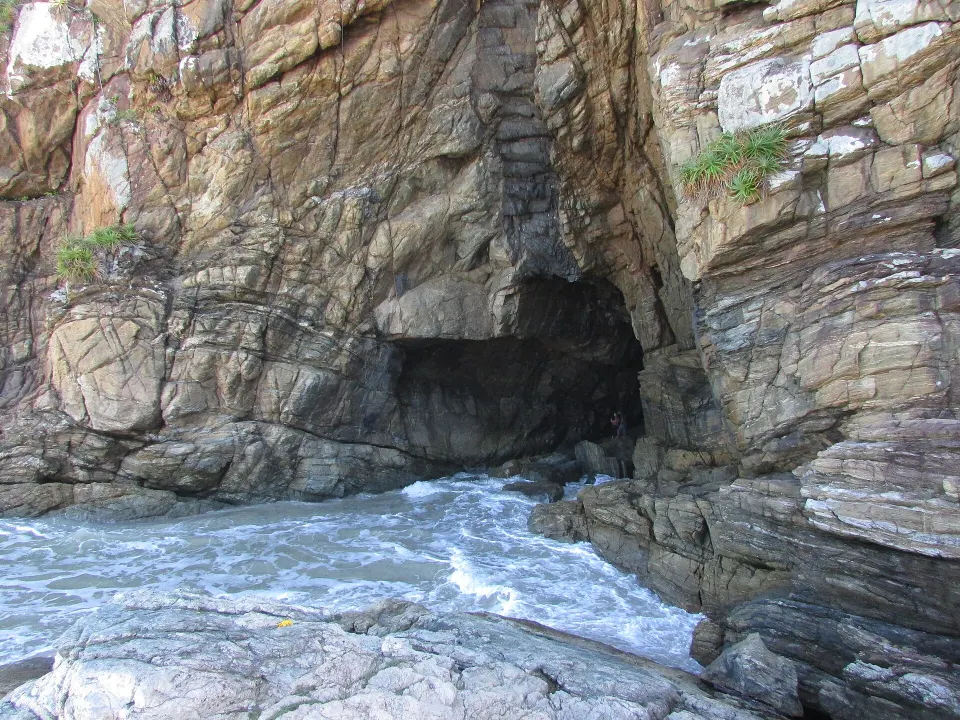
Original photograph of the rocky sea cave Gruta das Encantadas on Ilha do Mel near Encantadas, Paraná
Photo: Sergio Garcia / Wikimedia Commons · CC BY-SA 3.0 · Cropped for layout

A southern landmark beside the sea

Gruta das Encantadas: a cave shaped by the coast

This original 2013 photograph by Sergio Garcia shows Gruta das Encantadas, the well-known sea cave on Ilha do Mel’s southern side. IAT places the signed approach at around 600 metres from the Encantadas pier, making it a sensible local outing if you sleep nearby. It is not the same walk as the lighthouse or northern fort. Rock surfaces can be slippery and access near the ocean varies with waves and tide, so respect any closures and avoid entering exposed parts during rough conditions.

Follow the four-day island itinerary

Travel styles

Who does it suit?

These comparative scores show who is likely to enjoy this destination most—and where expectations may need adjusting.

Repeat Brazil travellers10/10
Slow travel10/10
Active travellers10/10
Backpackers10/10
Couples10/10
Friends9/10
Families with teenagers8/10
Solo8/10

Brasilll

How long should you stay?

Four to five nights is ideal. Three can work, but boat timing, weather and walking mean the island feels better when you do not need every day to be efficient.

Four or five nights are worth it if you want the slower rhythm rather than a hurried boat excursion. Nova Brasília is the more logical base for Farol das Conchas and the long walk to the fortress; Encantadas better suits the southern side and Gruta das Encantadas. IAT describes around four kilometres of trail from the Brasília landing to the fort, about 600 metres from the Encantadas pier to the cave and a staircase of roughly 150 steps at the lighthouse. These numbers are more useful than assuming all landmarks are next door because the island is small.

Check boat timetables directly with the current operator and do not schedule a tight onward connection in bad weather. As of IAT's 15 October 2026 update, the new digital access system was in its residents-only registration phase; the tourist start date had not yet been announced and no admission charge applied to that initial phase. Rules may change, so consult IAT again just before departure rather than presenting a proposed future tourist fee as a current ticket. Travel light, take shoes suitable for sand and stone, and leave room for rain or stronger surf.

Found an outdated price, route or detail? Send the page URL, the information that needs changing and a supporting source if available.

Report an error →

Does this sound like your Brazil?

Use Find Your Brasil to compare this destination with the rest of the country using your own priorities.

Plan Brazil

Getting there & moving on

Use these rounded door-to-door estimates to judge the travel day. Confirm the actual service and departure time before booking.

Main planning gateway

Curitiba

Typical access Road · Boat / ferry
Gateway transfer Road + boat · ~3 h Regular connections · Half-day transfer

Start by checking arrivals into Curitiba, then confirm the onward transfer to this destination. Boat or ferry stages make timing more dependent on the connection sequence, so avoid planning a tight onward commitment.

Good onward connections

These are selected options for your next stop. Confirm operating days, connections and total travel time for your dates.